

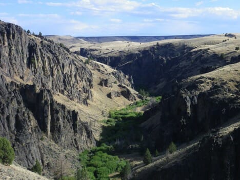
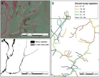
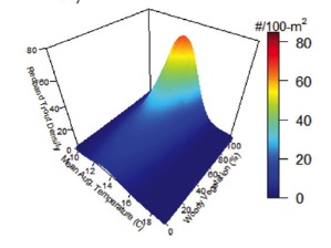
Above: Classic redband trout habitat in the Owyhee desert of Idaho – a ribbon of green among spectacular canyons. (Photo: Robin Bjork) By Kurt Fesenmeyer Redband trout in the high desert regions of Idaho, Oregon, and Nevada are tough fish – they persist in small, cool, and shaded headwater streams in a hot, arid environment. They are also tough to study – the region is one of the most remote in the Lower 48. Anglers and scientists have long appreciated what makes great trout habitat – cool and clean water, good food sources, and complex habitats. That’s certainly true in the high desert, but staff from TU’s science program hypothesized that we could learn more about redband trout distribution and abundance if we could accurately map the ribbon of green in the desert – those dense stands of willows and cottonwoods where redbands hole up. (Left: Example aerial photograph, B: Example map of woody vegetation, C: Vegetation map applied to streams) So, we automated the process used by many anglers – scrolling through online aerial photos to scout habitats along streams – to produce a high resolution map of vegetation along streams across more than 1,000 miles of redband habitat. When we coupled the vegetation maps with field surveys of redband trout and newly available maps of summer stream temperatures, we were able to predict not only which streams have redband trout, but also how abundant they potentially could be. Interestingly, we were able to do this more effectively with our maps than with habitat measures collected in the field. Our expectations were confirmed – cool streams lined with willows, alders, and cottonwoods are most likely to have redband trout, and those streams with both cool temperatures and woody vegetation have the most abundant fish. We suspect that the vegetation makes those coolwater habitats more productive by providing shade, feeding the bugs that feed the fish, and creating habitat complexity like pools and undercut banks. redbands03.jpg (Left: Predicted densities of redband trout relative to August stream temperatures and woody vegetation) Existing populations of redband have been greatly reduced by water diversions, livestock grazing, mining, and the introduction of non-native species such as smallmouth bass. In addition, changes associated with rapid climate change may increase summer temperature and expand wildfire and prolonged drought, which would threaten remaining populations. By creating a shortcut for locating those populations with the most available habitats and the most fish, we can more efficiently guide conservation efforts for these tough fish in a very remote area by protecting stronghold populations. And by identifying the sweet spot of stream temperature and streamside vegetation that redband like, we can restore those streams that may currently provide marginal habitats, but have the potential to support larger, more widely distributed redband populations. That’s not only a win for redband trout and the adventurous anglers that pursue them, but also for the whole suite of high desert wildlife – from bighorn sheep to greater sage grouse – who seasonally use streamside habitats. TU’s research was supported by the Bureau of Land Management. For more information, read the American Fisheries Society blog or read the full article: Daniel C. Dauwalter, Kurt A. Fesenmyer & Robin Bjork (2015) Using Aerial Imagery to Characterize Redband Trout Habitat in a Remote Desert Landscape, Transactions of the American Fisheries Society, 144:6, 1322-1339.